Trail Buddy - Review

Trail Buddy is a location tracking application for your Windows Phone that can be used for hiking, biking, geocaching and other activities that require GPS and/or mapping. Trail Buddy's features include:
- Create multiple trails with waypoints (aka points of interest) and tracks
- Start, pause, stop track recording and view current location information on one easy-to-read page
- View your location, waypoints and track on a map (accessing maps requires a good quality connection)
- View accumulated stats at any time for the current trail
- Pre-define waypoints or capture your current position along a trail - you can even set a waypoint from the map
- Take pictures directly from the waypoint page
To see how well these features work out for Trail Buddy, take the jump past the break.
App Layout
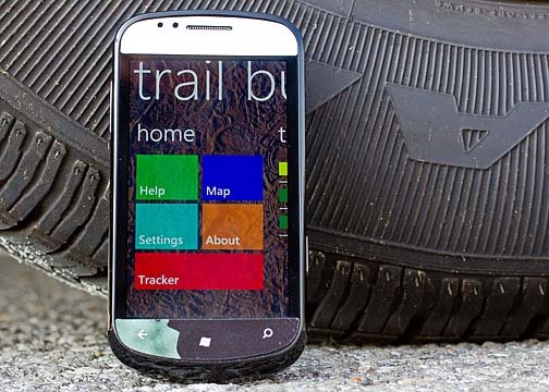
Trail Buddy is laid out nicely making the most out of the Windows Phone Metro Style. The Home Page has tiles to access the Help Section, Maps, Trail Buddy's settings, read About the app, and skip over to the Tracker feature.

Trail Buddy's Help Section is an extensive guide for using the app with quick links to get you to certain areas of the Section and the text is touch zoomable for easier reading. It also supports horizontal viewing for easier reading as well.

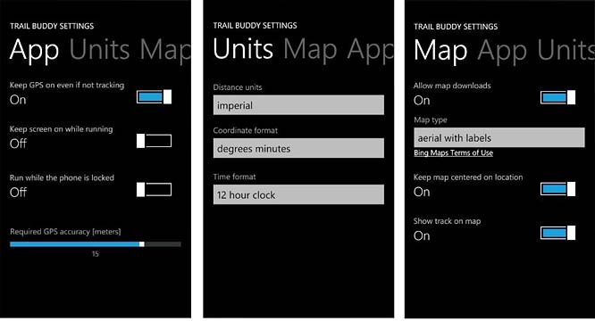
Settings cover how you want the application to perform (gps on/off while not tracking, keep the screen on, etc.), how you want your units of measurement displayed, and map options. Trail Buddy uses Bing Maps and you can choose between three map styles; aerial, road and aerial with labels.
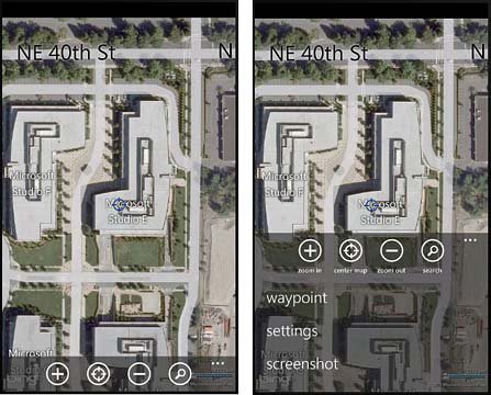
The Map view includes a handful of button controls along the bottom of the screen. You have controls to zoom in, center the map on your location, zoom out, and search. The three-dot menu pulls up commands to set a way point, access your settings, and capture a screenshot.

Asides from the Home Page, Trail Buddy also has pages that will list your trails, waypoints, active tracks, and trail statistics. The Trail Page is basically a collection of your recorded tracks that were generated from the Tracker Page.
All the latest news, reviews, and guides for Windows and Xbox diehards.
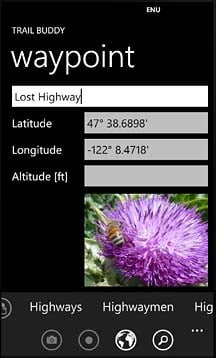
While you can set a way point from the map view, you can also create way points from the Way Point Page. You enter a descriptive name, the latitude/longitude is automatically recorded (you can override this if your not at the way point's location) and have the ability to use your Windows Phone camera to further document the way point. Additionally, way points can be shared via email or SMS with others.

To review a previously recorded track or trail, tap on the listing on the Trail Page to highlight the particular track. Then go to the Home Page and tap the Map Button. Your trail will now be pulled up on the Bing Map, highlighted by dots. Bread crumbs came to mind when I first saw the dotted line and would have preferred a solid, highlight line to represent the track. The dotted lines work but on the move may be hard to pick up at a glance.
When you highlight a previously recorded trail, any waypoints associated with that trail will be displayed on the Waypoint Page and the trail's stats will be displayed on the Stat Page.
Performance
In taking Trail Buddy out for a test drive, the app did a decent job of pinpointing my location with accuracy and compiling my travel stats. Waypoints were simple to create and the camera function was a nice addition to document things.
Map load times were noticeably slow and I don't know if it's a software issue or due to the amount of information the app is pulling from Bing. At first I thought the lag time was due to a poor data connection but the lag times were consistent even when a full signal was present.
The interface takes a little getting used to as well. There's a lot of back-and-forth movement to get to where you want. For example, I think it would be better to have a button on the trail description page to view the track on the map. Instead you have to highlight the trail, then go to the Main Page and then tap the map tile. The app navigation won't drive you crazy but it will take a little getting used to.
The one nice feature of Trail Buddy's map display is the ability to capture screen shots of the map. You can document your starting point, where you parked your car, where your hotel might be, or your camp site location. It's a nice feature should you loose your data connection.
Overall Impression
Trail Buddy is more than a track back application such as BaseCamp but not as en-depth a tracking application as Outdoor Navigation. Trail Buddy rests somewhere in between the two. Trail Buddy has plenty of features to make it a very useful outdoor tracking app and avoid being overwhelming. In using the waypoints, I can see Trail Buddy being very useful as a geocaching app.
One downside I found to Trail Buddy is that at times it took a considerable amount of time to load the maps and acquire a GPS fix. There are a lot of variables involved in this so I can't place all the blame on the application but it was noticeable.
I do wish the trails were marked on the maps with a solid line that was easier to pick up on and the navigation was a little smoother. To Trail Buddy's credit these aren't critically fatal flaws but instead simply features you have to get used to.
All in all, Trail Buddy is a nice, "notch above basic" tracking and mapping application for your Windows Phone. There is a free trial (as opposed to trail) version available for Trail Buddy and the full version runs $.99. You can download either over here (opens Zune) at the Marketplace.

George is a former Reviews Editor at Windows Central, concentrating on Windows 10 PC and Mobile apps. He's been a supporter of the platform since the days of Windows CE and uses his current Windows 10 Mobile phone daily to keep up with life and enjoy a game during downtime.
